(クリックで拡大)
小学校の校歌、中学の校歌、高校の校歌、いずれの中にも登場し、万葉集でも歌われた多摩川の土手のサイクリングの御案内です。
This is an intruduction to the bike trail on the bank of Tama-gawa river,
which is sung in the school songs of my elementary, junior high and senior
high schools as well as in the Manyo-shu collection of poems.
2021年3月18日時点の情報です。アップデートに努めたいと思いますが、完全ということにはならないと思います。御容赦下さい。
The information is given as of 18 March 2021but may not be perfect.
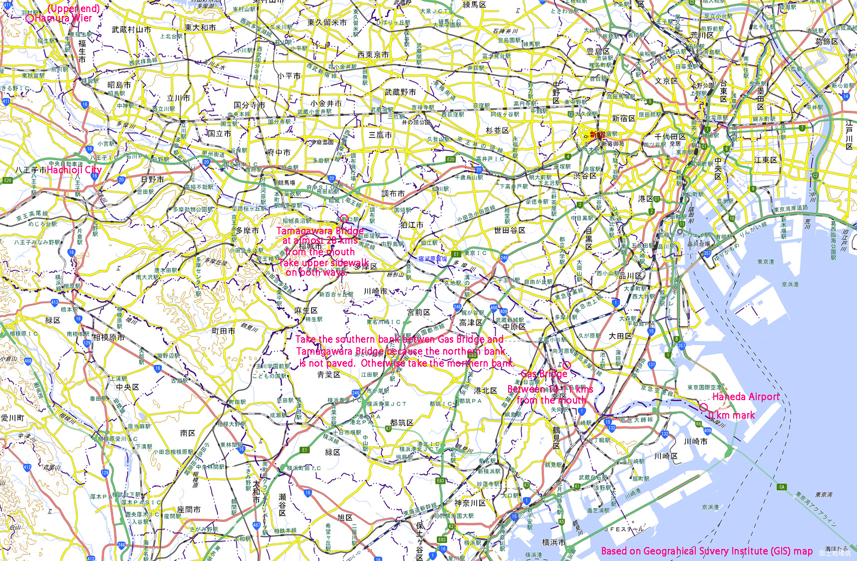
土手の舗装が連続している羽田空港横の河口から、玉川上水の取水口である羽村堰まで。羽村堰は、河口から53キロポストの少し上流にあります。下記のように、途中で橋を渡って右岸(南岸)に渡らなければならないので、河口からの走行距離は55キロ余りになります。
From the river mouth next to the Haneda Airport up to the Hamura Weir which
takes water for urban Tokyo. The distance to the Weir from the river mouth
is a little more than 53 kilometers. Because we must cross the bridge twice
on the way, we should count 55+ kilometers for the total ride.
自転車道は、土手から降りて車道の橋の下の河川敷を回り込むなどするので、自分で選択しない限り、道路の横断はありません。
We do not stop at traffic lights all the way because the bike trail runs
under bridges.
北岸の狛江市域から丸子橋付近にかけては舗装されていません。そのため、調布市内の多摩川原橋(河口から28キロ弱。橋のすぐ上流側に28キロポストがありますが、しばしば草に埋もれているなどしていて見落とします。)からガス橋(河口から10キロと11キロポストの間)の間は右岸(南側)を、それ以外は左岸(北側)を走ります。多摩川原橋は、下流側ではすぐに自転車道に戻れない上、交通量の多い車道を走って自転車道に戻る構造になっているので、往復とも上流側の歩道(幅が広く、自転車通行可のはず。)を通ります。多摩川原橋の1本上流の是政橋で対岸に渡ることも可能ですが、右岸側の舗装は、桜の根で持ち上げられるなどして凹凸が多いので走りにくいです。
The section between the Komae City area and Maruko Bridge is not paved.
Therefore we should take the right (southern) bank between Tamagawara Bridge
(almost 28 kilometers from the river mouth) and Gas Bridge (between 10-kilometer
and 11-kilometer posts). Othewise we should take the left (northern) bank.
It is possible to take the Koremasa Bridge instead of Tamagawara Bridge.
But the pavement between Koremasa and Tamagawara Bridges is damaged by
cherry tree roots and is bumpy.
今の多摩川は、昔の多摩川が作った扇状地である武蔵野台地(だから、小石と砂と土でできていて、地下40m以上を掘っても崩れるのです。)の南の縁を流れ、南側には多摩丘陵があります。そのため、南側(右岸)には土手も道も無いところがあり、そういったところでは、自転車の場合は丘陵の上を迂回することになります。また、北側で合流してくる河川は、台地の段差等から湧き出した小河川ばかりであるので容易に越えられるのに対し、南側で合流する河川は、多摩丘陵の間で水を集めたもので、比較的大きいため、自転車では、合流点近くで、合流河川の上流側に迂回を強いられます。そのため、多摩川原橋・ガス橋区間以外では、北岸を走ることになります。
The current Tama River flows at the southern edge of the Musashino Plateau
which is actually a delta formed by Tama River in old times, and sometimes
touches the northern slopes of Tama Hills. At such places, there are no
banks, nor roads or bike trails.
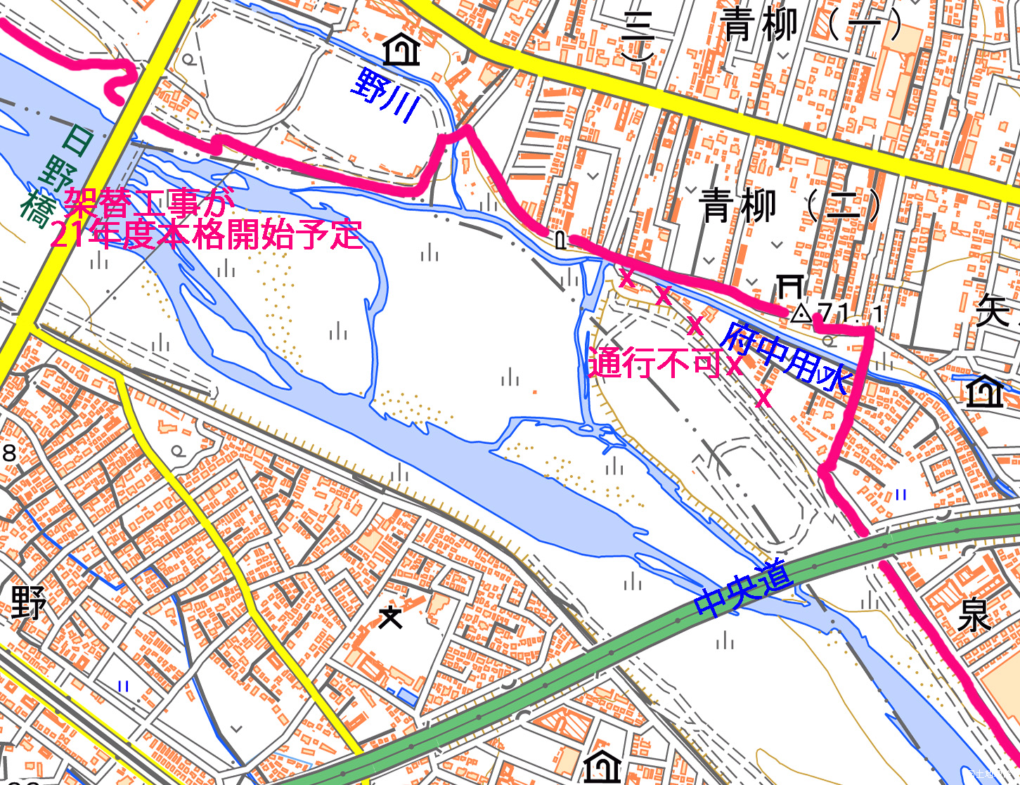
左岸(北岸)でも、中央道の橋のすぐ上流(万願寺渡船場跡)から日野橋の下流までは住宅地内の狭い道を迂回する必要があります。特に、下流側から来た場合、堤防はもう少し先まで伸びていますが、行き止まりになります。中央道の下をくぐったら、すぐ先で右の車道に降り、台地上に少し上がり始めたところで左の道に入り、道なりに行くことで、日野橋の少し下流で土手に戻れます。(工事の状況を見ると、この区間も舗装自転車・歩行者道でつながる可能性があると思います。)
Even on the northern side of the river, there is no trail in a section
between Hino Bridge and the Bridge of the Chuo Expressway. There we must
detour on narrow lanes in the residential area as shown in the map.
(クリックして拡大)
(国土地理院地図を利用して作成)
(3月18日、新しい日野橋の橋脚建設が日野側(南側)で始まっていました。)
そのほかにも多少わかりにくいところがあり、ルート・ファインディング能力が試されますが、多少間違えても重大な支障は生じないと思います。
There are some other points where root finding capacities are requried.
But taking a wrong way may not lead to serious problems.
第二京浜の橋の少し下流から東海道線鉄橋の少し上流までの間は、よく見ると、土手から降りて河川敷内にある道を走るように指示されているのですが、この区間の河川敷の舗装路は、雨が降ると何日もの間水没すること、そうなると泥の多い草地を迂回するしかなくなること、乳幼児連れの人が多いこと、上流側の下降路は、車いす用のもので、幅が狭く、車いすの人や杖をついた人との安全なすれ違いが困難であることから、適切な指示とは思えません。この区間も土手上を走るのが安全だと思います。土手上のほうが幅もずっと広くもあります。
There is a section between the bridge of the 2nd Kei-Hin Bypass and the
bridge of the JR Tokaido Line where signs instruct to run on the trail
in the dry river bed. But this river bed is covered with standing water
after rains and therefore we are forced to run on muddy grassland. Also,
there are young parents strolling with small children on the riverbed trail.
Furthermore the pedestrian way down to the river bded is for wheelchaired
people and is narrow. Therefore I believe that running on the bank is rational.
なお、羽村堰より上流は、山が迫って来るので、土手は無く、更に上流を目指す人は一般道を走ることになります。路側帯がほとんど無い一方、ダンプカーが多く、更にだんだんとトンネルが現れるので、怖いと思います。
There are no more bike trails upper than Hamura. If you go further, you
must take narrow roads where many dump trucks are runnning and where there
are futher narrower tunnels. It is scary.
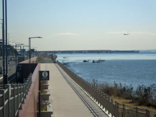
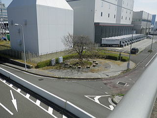
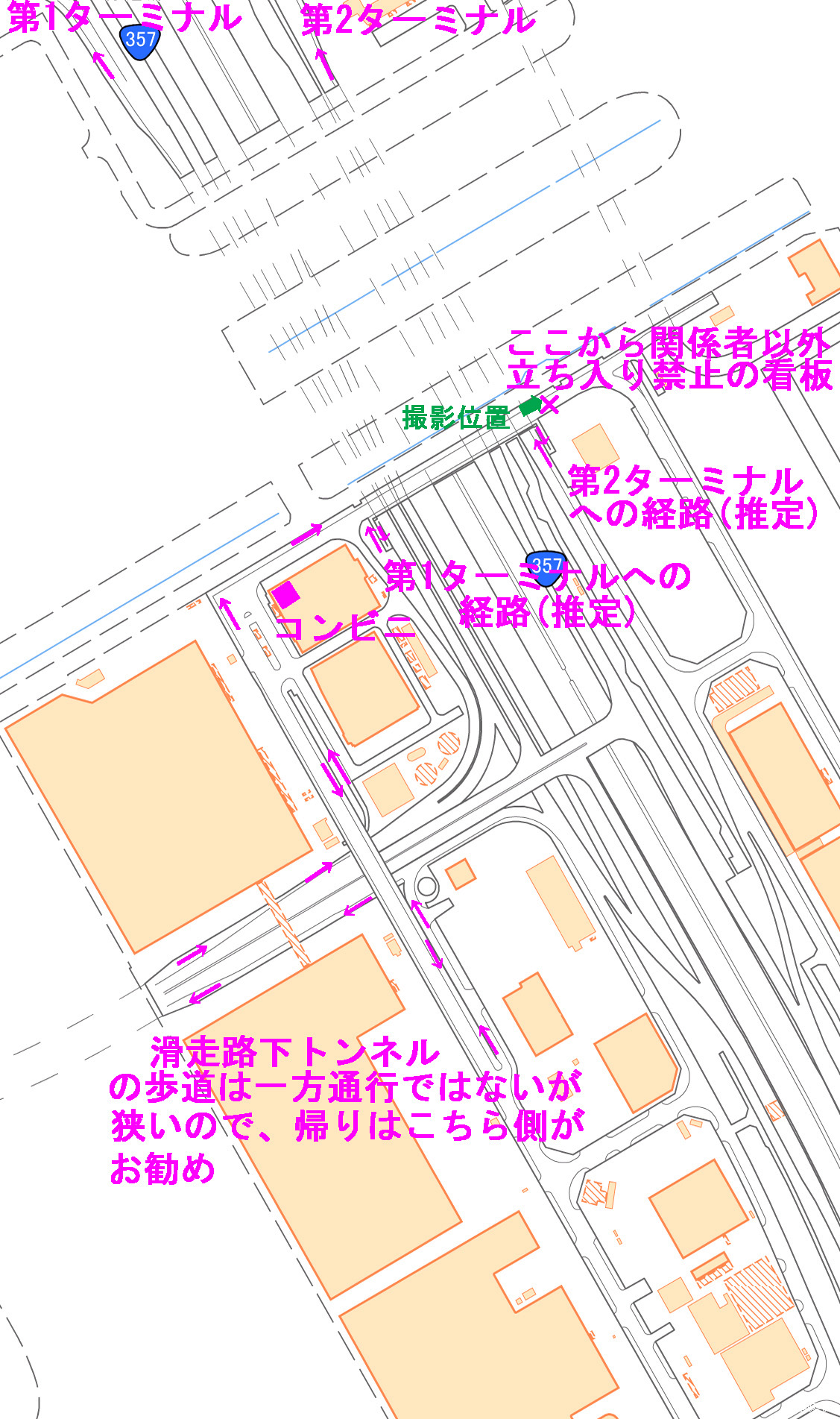
羽田空港島に渡ってすぐのところにある赤い旧穴守稲荷神社大鳥居を折り返し点として選択する人が多いですが、そのすぐ河口側にある旧滑走路の下のトンネルをくぐって、もっと下流まで行けます。旧滑走路付近を含む羽田空港沖合移転で空いた区域は再開発工事が進んでいますが、自転車走行指定部分を含む広い歩道付きの道路が、第3ターミナル(国際線ターミナル)付近までできています。この第3ターミナル入り口付近の多摩川べりは、公園として整備され、毎日清掃されている新しいトイレもあり、飛行機も見えるので、折り返し点として適していると思います。ベンチがもう少し多いといいのですが。現在は極めて人が少ないですが、コロナのために営業開始を延期している施設等が営業を始め(温泉は既に営業しています。)、また、空港利用者が回復すれば、公園を散策する人も格段に増えるものと思います。河口橋(名称募集中)の工事のため、2021年2月時点で右側歩道が通行止めになって左側を迂回しなければなりませんでしたが、3月18日には通れるようになっていました。
Many people take the red shrine gateway as the lower end of the run. But
it is possible to go further down beyond the tunnel under a former runway
next to the shrine gate. Soon after the tunnel, we come to a new road with
pedestrian and bike ways. Near the entrance to the Terminal 3, a park has
been constructed with two public toilettes. This may be a good end of the
bike ride. But it may be crowded when the new buildings and facilites are
open when the COVID comes to an end.
この公園のすぐ先、貨物ターミナル入り口のすぐ先には、多摩川管理のための河口からの距離の測定の起点となる0キロの金属標識があります。もっとも、羽田空港の沖合移転の結果、ここは、現在では、実態上河口ではなくなっています。多摩川の土手(両岸)には、河口から1キロ毎にステンレス製の標識柱が立ち、河口からの距離がわかるようになっていますが、この金属標識がその起点です。
Soon after the park is a 0 kilometer sign of Tama River. The river banks
on both sides actually have metal posts every kilometer towards the upper
stream.
第3ターミナルより先に行くことも可能です。しかし、その先の滑走路(第1ターミナル側のA滑走路)の下の曲がったトンネルの入り口からは、自転車の車道走行が禁止され、かわりに歩道走行可能とされているので、歩道を走らなければなりません。この歩道は、トンネル内では狭いので、すれ違いには注意を要します。
We can go further. The main lanes of the road under the runway A (Terminal
1 side) are closed for bikes. Instead running on the pedestrial lane is
allowed. But we must be careful of the bikes coming from the other direction
because the pedestrian way is narrow.
右側の歩道を行くと、トンネルの先に大きな桜の木とベンチがあり、ここが実質的終点です。ビルの間で、見晴らしは良くありませんが、暑い時には日陰とベンチがあり難いです。右に行く道の入り口には「関係者以外立ち入り禁止」の表示があります。まっすぐ行く道は、すぐ先で首都高9号線(湾岸線)に突き当たって終わりです。
If we take the right side pedestrian way, we will reach a cherry tree with
a few benches. This is the virtual end of the bike ride because the pedestrian
way soon ends facing an expressway and because the enternace to the right
road is prohibited. There is no good view here but the cherry tree gives
a good shade in hot seasons.
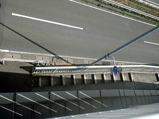
 滑走路下右の歩道を行った先の桜。 橋の上から見下ろす。 Google衛星写真 |
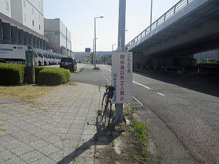 桜の脇の関係者以外立ち入り禁止の表示 |
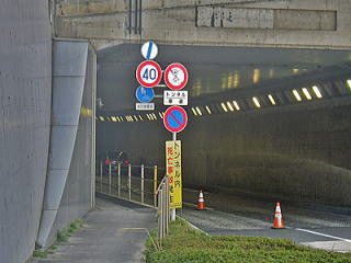 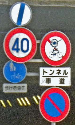 滑走路下の通行指示標識(桜の側の入り口) |
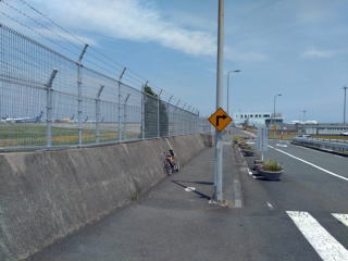
左側の歩道を行くと、トンネルの先で、歩道だけ左に登って行き、すぐに、橋を下りてきた車道に合流します。そのまままっすぐ進むと、第1ターミナル側のA滑走路と第2ターミナル側のC滑走路を繋ぐ飛行機の通路に突き当たります。ここの角には、コンビニ(ファミリーマート)があります。この飛行機の通路に沿って右に進むと、すぐに、中央が首都高、両側が国道357号線となっている幅広い道路の上にかかる橋になります。この橋の上から、滑走路間を移動する飛行機を見ることができるので、ここも折り返し点候補です。(但し、2021年2月時点では、コロナ禍で便数が減っているので、ここを移動する飛行機の数もかなり減っているように思います。)なお、この橋を渡った先は、「関係者以外立ち入り禁止」です。
If you take the left-side pedestrian way under the runway, the pedestrian
way climbs the slope to the left, leaving the road but soon merges another
road and then hits a fence of the connecting runway between runway A (in
the Terminal 1 side) and runway C (in the Terminal 2 side). If you turn
to the right here (where there is a convenience store), you will come to
a bridge over the expressway and national highway. This is a good place
to watch aircrafts running between the two runways. You are not allowed
to go further straight after the bridge.
しかし、この下の国道357号線には、この橋の下のところから、第1・第2ターミナルに向かって自転車通行可の歩道がついていて、しかも、この橋からは斜路付きの階段でその歩道に降りることができます。手前側(国道357号線の左側)の歩道を進むと第1ターミナルに到達します。第1ターミナルと第2ターミナルの間の中央部付近には橋が2本架かっているので、その歩道部分を渡れば第2ターミナルにも行けるはずです。どうやって2階に上がるのかが未解明ですが。また、飛行機の通路の橋から降りて357号線の右側の歩道を行けば第2ターミナルなのですが、グーグルの衛星写真を見ると、あまり行きやすくないかもしれません。
But there are pedestrian ways on both sides of the national haighway under
the bridge and there are stairs with slopes for bikes from the bridge to
the pedestrian ways. The pedestrian way on the left side of the road takes
you to the Terminal 1.
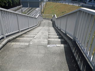 第1ターミナルに行ける歩道に降りる斜路付き階段 |
 斜路付き階段入り口から下の歩道を見下ろす。 |
A滑走路下のトンネルの下の道路の歩道が狭いので、帰りには、道路の左側の歩道を走ったほうがいいかもしれません。A滑走路下のトンネルを出てから左に登って合流した車道の橋を渡って道路の反対側に出れば、上記の桜とベンチのある場所に降りられます。そこの入り口には「関係者以外立ち入り禁止」の看板があるわけですが、反対側からだと、そのような表示がありません。見た記憶がないし、また、グーグルのストリートビューを見てもありません。そもそも、グーグルのストリートビューを撮影している車は、「関係者以外立ち入り禁止」から入り込んで道路(車は一方通行)を走って撮影しているのですが。
このトンネルを出て坂を登り切ったあたりで、先行の自転車も私の自転車もパンクしました。よくある空気圧不足によるものとは考えにくく、また、チューブには針で刺したような穴が開いていました。歩道に生えている草の中に針のようなものがあった可能性があります。
羽田空港には、関係者以外立ち入り禁止のところが多かったり、警察官が多かったりするので注意しましょう。歩道を走行していたら警察官に降りるように言われたという情報がネット上にいくつもあります。私は、自転車から降りるように言われるようなところは走っていないはずですが、警察官に呼び止められ、防犯登録のチェックをされました(警察官はスマホでネットに接続し、私の自転車が防犯登録がされていることを確認しました。)。私の自転車は米国で買ったもので、長く、日本の防犯登録をしていなかったのですが、その1か月前にたまたま立ち寄った自転車屋で防犯登録できるということだったので登録したばかりでした。
There are many police officers in this area. There are postings of the
warnings given by police officers to the bike riders who were running on
the bike on pedestrian ways that were not allowed for bike ride.
(クリックして拡大)
(国土地理院地図を利用して作成)
羽村堰以外に考えられません。玉川兄弟の碑などもあるごく小さな公園になっていて、トイレもあります。ここからは、多摩川を対岸に渡る歩道橋があり、多摩川を眺めるのに良い墓所ですが、歩道自体は、多摩川対岸にある羽村市の飛び地の住宅地の住民のためのようで、その先に自転車道はありません。
There are no other significant choice than the Hamura Weir. It is a small
park with a statute of the Tamagawa borthers who constructed the water
canal to Tokyo from here. Here is a pedestrian bridge over the Tama-gawa.
It is a good view point of the river. However, it seems that the bridge
is for the residents in the oppoite side of the river - The other side
of the river is a kind of isltand of the Hamura City.
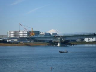
なお、多摩大橋(八王子市と昭島市の間。国道16号より1本下流側。北行き車線には赤っぽい色のアーチ。)から上流は、多摩川の勾配がやや大きくなります。ここを下る時にはスピードが出やすいですが、堤防自体の幅が狭いこと、舗装の状態が必ずしも良くないこと、ランナーや歩行者も多いことから、注意を要します。
After Tama O-hashi bridge, the river is steeper. Be careful of your speed
in coming down.
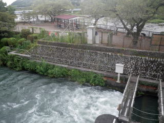
河川敷が公園や運動場になっているようなところも多いので、あちこちにあります。使ったことのある2か所のうち、羽田空港第3ターミナル入り口付近の公園のトイレは、新しく、きれいです。もう1か所の二ヶ領宿川原堰のところの展示施設の敷地内のトイレもまずまずかと思います。
No problem in finding public toilettes because there many small parks on
the way. The one in the riverside park next to the Haneda Airpor is new
and clean. The one in the complex in Shukugawara Weir was also OK. I have
not checked the others.
何と言っても、乳幼児連れを含む歩行者、ランナーが多いので注意。ライダーにも、35キロ程度の高速走行の人たちがいます。残念ながら、ライダーの中には、自己中心的な人もいます。条例で義務にもなっていますが、加害者になるリスクもあるので、賠償責任保険には入りましょう。賠償額無制限のものでも、掛け金はさほど高くありません。自転車専用保険以外に、自転車での加害を含む日常生活での賠償責任を広くカバーしているものが良いと感じます。私はそういう保険を自動車保険に付帯させてカバーしています。
Be careful that there are many pedestrians, including very young children,
and joggers. There are also fast bike riders running around 35 kilometers
per hour. Regretfully, not all the bikers are concious of other people.
It is obligatory by local enactments that bike riders must subsribe to
ensurance to cover their indemnity liability.
工事による迂回等があり、それが、工事の進捗状況によって変化します。注意標識を見落とさないことや、誘導員の指示に従うことで切り抜けます。2021年2月時点では、羽田空港付近の沖合移転で空いた区域の再開発に関連した道路の移転・整備、河口橋の建設工事、関戸橋(府中市と多摩市の間。京王線鉄橋のすぐ下流)の架け替え工事、日野橋(立川市と日野市の間)の架け替え工事が進行中です。福生市南端の河川敷にある福生南公園は、2019年秋の台風で破壊され、園内を通る自転車道も通行止めになっていましたが、2020年11月から通行できるようになりました。公園内の上流側は舗装されていませんが、通行に支障はありません。2019年の台風で傷んだ部分はたくさんあるので、施設等の補強工事や修復工事はこれからも続いていくものと思います。
Take note that the situation of the trail is ever changing. Often there
are detours. Currently in February 2021, the re-development of the area
of the previous runways in Haneda Airport and construction of a river-mouth
bridge are going on. Also, reconstuction work of the Sekido and Hino Bridges
is going on. Provisional restoration of Fussa Minami Park in which the
bike trail runs now finished and bikes can go through the park since November
2020. But the upper section of the trail has not yet been paved. There
have been many other repair and re-constuction works to cope with the damages
caused by the typhoon in 2019.
ネット上にたくさんの情報があります。上記のように工事等により日々変化があるので、いつ時点の情報かに注意しましょう。
There are many information sources in the Internet. But some many be old.
Be careful of the date of the information.
国土交通省京浜河川事務所「多摩川散策マップ」は、自転車道の地図ではないものの、河口からの距離、トイレ、施設等が示してあって便利です。但し、2006年のもので、情報が少し古くなっています。例えば、羽田空港沖合移転で空いた区域の施設は示されていません。Although this is not for bikes, this map is useful with information of distance from the river mouth, toilette, palces of interest etc. But the information is a bit old pubilshed in 2006.
東京都都市整備局の「たまリバー50キロマップ」も便利ですが、東京都庁作成のものであるので、多摩川左岸(北岸=東京都側)しか示していず、左岸の未舗装区間も通らせる地図である点、要注意です。また、いつの時点の情報かが示されていない点にも課題があります。Unseful information for bike ride. But because it was published by the Tokyo government, the information is given as if you had to run on the Tokyo side despite the sheer fact that certain sections in Tokyo are not paved. Also, the lack of information of the publication date is a problem.